|
PolyLineEdgeFaults
finds edge faults and missing points along the lines of multiple polygons.
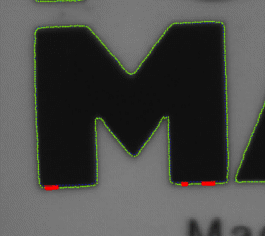
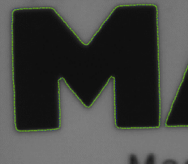
The advanced polygon match fitting ensures that each character is fitted
with subpixel precision. With high quality image - translation, rotation,
size and skew is optimised before edge fault detection. Below the character
M to the left is fitted with translation and rotation - to the right it is
fitted with translation , rotation, size and skew. False edgefaults are
found on the character only rotated and translated into position. In the
example the edge is sampled with a steplength of one pixel.
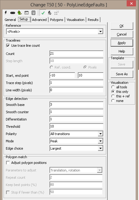
Setup
Reference - Reference system selection
Global position
- Offset in X - offset x in reference coordinates
- Offset in Y - offset y in reference coordinates
Trace lines
-
Count - number of
trace lines
-
Start point - position of
starting point on trace line given in reference coordinates
- End point - position of
end point on trace line given in reference coordinates
- Inverted the sign of start
and stop point will change the direction of the trace comb
Trace step (pixels)
- normally 1 - given in pixels
Line width (pixels) - 0 - trace line is not averaged - a higher
value will average N pixels perpendicular to the trace comb
Edge detection
- Smooth base - 3 is normally a good value
- Smooth counter - 1 default - given i pixels
- The smoothing increasing with higher values
- Differentiation
- 0 - give threshold
- 1 - 1. order differentiation - the derivative - default normally
used
- 2 - 2. order differentiation
- Threshold - the threshold or sensitivity of the edge detector -
a lower value increases the sensitivity
- Polarity - All transitions | Light to dark | Dark to light
- Mode - Peak | Threshold
- Edge choice - First | Largest | Last
Polygon match - select adjust polygons positions and
the polygon is fitted before edge detection
-
Repeat count - the number of iteration to
fitting the polygons
-
Parameters to adjust
-
Translation, rotation - default
-
Translation, scale
-
Translation, scale, rotation and skew
-
Keep best points ( % ) - specified the number of
edge points used for iteration - a lower value makes it more robust -
default is 80%
-
Stop if fewer ( % ) - terminates iteration when
less than edge points in % is located - default is 50 % and deactivated
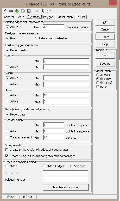
Advanced
Missing edgepoint interpolation - Interpolate
missing edgepoints
Faults (polygon mismatch) -
-
Report faults -
-
Min/Max Depth -
-
Min/Max Width -
-
Min/Max Area -
Gaps (missing edgepoints) - Gaps
are defined as number of missing points in sequence.
String result
Trace line samples dialog - a helper window to set trace line
filter parameters and thresholds
- Middle - show the middle traceline
- Middle+edges - shows the first, middle and last traceline
- Selection - show the selected tracelines
- Line indices - traceline selection
- example: 2,3,12-15
- example: 1 3 5 7
- Show trace line popup - activates a modeless traceline window
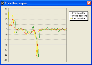
Example tracelines - Middle+edges is selected
Polygons
Line definition file - The paths
to be searched are initially read from a text file (see the StrVec
format). The name of that file is also stored, for possible future
reload. The path information, however, is stored directly in the
system, without need for the external file.
You can browse for or manually edit the filename; by clicking
"Load", the file is read and its contents stored internally.
Polygon
properties
Search area
- Vector - list of numbered polygons
- Content - the points of the selected polygon
- New - add polygon
- Delete - remove selected polygon
- Up - Move polygon up in list
- Down - moves polygon down in list
- Grid - activate dialog for making polygon grid
- Paste new - creates a new polygon, pastes the polygon from the
clipboard and presses apply - this is the quickest way to create many
polygons
- Highlight selection - highlights the selected polygon in the
image
- Copy - copies the selected polygon to the clipboard
- Paste - pastes the clipboard to the selected polygon - will overwrite
an existing polygon
Note: Copy is used to transfer polygon to the image for editing
and modification. The edited polygon is pasted back to the tool using Paste
Vector mouse menu - activate by right mouse clicking in
the Vector list
-
New - creates a new vector
-
Delete - deletes the selected vector
-
Grid.. - activate dialog for defining polygon grid
-
Paste new - paste clipboard as new polygon
-
Up - moves polygon up in list
-
Down - moved polygon down in list
-
Delete all - removes all polygons from list
-
Delete empty vectors - remove all empty polygons
Results
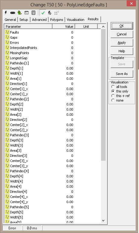
|
Number of
faults
|
Number of
faults found along the polygon
|
|
Number of gaps
|
|
|
Number of errors
|
|
|
Interpolated
points
|
|
|
Missing points
|
|
|
Longest gap
|
|
|
Line index
[n]
|
|
|
Depth [n]
|
|
|
Width [n]
|
|
|
Area [n]
|
|
|
Center [n].x
|
|
|
Center [n].y
|
|
|
EdgePoints |
contains all found edgepoints |
|
MatchPercent |
contains the polygon match fit percent for each polygon |
Visualisation
|
Center
|
|
|
Edge points
|
|
|
Fault
points
|
|
|
Fault
polygon
|
|
|
Fitted
points
|
|
|
Gap points
|
|
|
Missing
points
|
|
|
Path
|
|
|
Trace lines
|
The search
lines
|
ExecuteCmd support (see also executeCmd)
|
Command
|
Parameters
|
Return values
|
Comments
|
| Set |
Object=ROI;Value=<polygon> |
ok,None |
Sets
the first ROI polygon. See Copy/paste
ROIs for details. |
| Set |
Object=ROI;Number=<number>;
Value=<polygon> |
ok,None |
Sets
the numbered ROI polygon. See Copy/paste
ROIs for details. |
| Add |
Object=ROI;Value=<polygon> |
ok,None |
Adds
ROI polygon to the end of the list. See Copy/paste
ROIs for details. |
| Get |
Object=ROI;Number=<number> |
ok,<polygon> |
Gets
numbered polygon, as Scorpion polygon (StrArr format). |
| Get |
Object=Tuple;Number=<number> |
ok,<tuple> |
Gets
numbered polygon, as Python tuple |
| Clear |
Object=ROI;Number=<number> |
ok,None |
Clears
numbered polygon (makes empty) |
| DeleteAll |
- |
ok,None |
Deletes
all polygons |
Keyboard shortcuts - More
information
|
Shortcut
|
Command
|
Comments
|
| Ctrl-Z |
Set
ROI |
Sets
the selected polygon to points marked in the image. If only a single
point is marked, the polygon is moved, centered around the point.
If the tool dialog is not open, the first polygon is set. |
| Ctrl-1
- Ctrl-0 |
Set
polygon 0-10 |
Sets
the numbered polygon to points marked in the image. If only a single
point is marked, the polygon is moved, centered around the point. If
a new polygon is defined this way, any missing polygons in between
are set as empty. |
| Ctrl-Shift-1
- Ctrl-Shift-0 |
Clear
polygon 0-10 |
Clears
the numbered polygon (sets empty). |
|